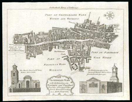
Lot 45002 - 1772c. printed map of Aldersgate ward with its divisions

1772c. printed map of Aldersgate ward with its divisions


Lot 45002 - 1772c. printed map of Aldersgate ward with its divisions

Great Britain » Postal History
Dear collector, we present you lot 45002 which you can now add to your Great Britain » Postal History collection. If you have any questions about our lots, please feel free to contact us here.
Estimate
400 - 500 GBP
Auction date
Tue 8 Dec 2026 at 14:00 (Europe/Zurich)
25d 17h 52m 19s before bidding ends

Description

1772c. printed map of Aldersgate ward with its divisions into precincts and parishes, showing St Martins Le Grand, the eventual site of the General Post Office; superb condition and makes a lovely addition to the story of a postal history exhibit. Rare so fine.

Please note that we are still working on adding images for the lots. If the lot you are interested in does not have images available yet, we invite you to check again in a few days.

If you still cannot find the images you are looking for in a few days, please send us a message. Important: don't forget to mention the lot number(s).

Thank you for your understanding.

© Copyright 2024-2025 - David Feldman SA - All Rights Reserved
chevron-downchevron-right-circle
linkedin facebook pinterest youtube rss twitter instagram facebook-blank rss-blank linkedin-blank pinterest youtube twitter instagram